First comprehensive measurements of sea level changes in the Baltic Sea and the North Sea
Precise data for improved coastline protection
For the billions of people who live in coastal areas, rising sea levels driven by climate change can pose an existential threat. “To protect people and infrastructure – for example by building flood protection structures, securing ports or making dikes higher – we need reliable forecasts on sea level trends,” explains Prof. Florian Seitz, the Director of the German Geodetic Research Institute (DGFI-TUM) at TUM. “However, this requires precise data with high spatial resolution. And until now, the required wide-area coverage was not available.”
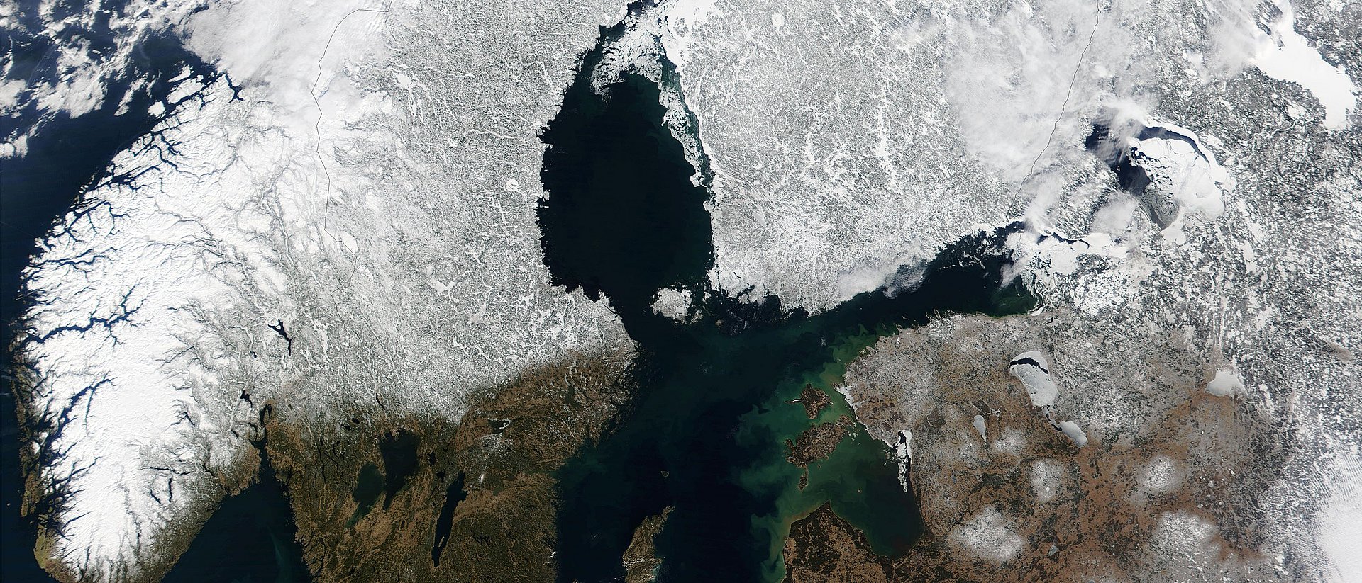
Especially near coastlines – where so many cities, ports, industry facilities and residential areas are located – the quality of data collected by the radar satellites orbiting the Earth for decades was compromised by high signal-to-noise ratios. The reason: Mountains, bays and offshore islands scatter the signals and distort the reflected echoes. Another problem is sea ice, which covers parts of the oceans in winter, and is impenetrable to radar.
In the Baltic Sea Level project (Baltic SEAL), a team of researchers at TUM worked with international partners to develop algorithms to process the measurement data from radar satellites to permit precise and high-resolution measurements of sea level changes even in coastal areas and beneath sea ice.
Penetrating ice and islands with radar
The researchers chose the Baltic Sea as the model region: “Data from this region are especially suitable for developing new methods because multiple factors make analysis difficult: The complex shape of the coastline, sea ice and wind. At the same time, there are plenty of local sea level measurements to corroborate the results,” says project leader Dr. Marcello Passaro. “An analytical method that works in the Baltic Sea can be easily adapted to other regions.”
To handle hundreds of millions of radar measurements taken between 1995 and 2019, the team developed a multi-stage process: In the first step, they calibrated the measurements from the various satellite missions so that they could be combined. With specially developed algorithms, they were then able to detect signals from the ice-covered sea water in the radar reflections produced along cracks and fissures. This made it possible to determine sea levels for the winter months. With new computational methods they also achieved better resolution of radar echoes close to land.
As a result, it is now possible to measure sea levels in coastal areas and compare the results with local tidal records. The processed data were then fitted to a fine grid with a resolution of 6 to 7 km using an algorithm developed by the team. The result: A highly precise data set covering the entire region.
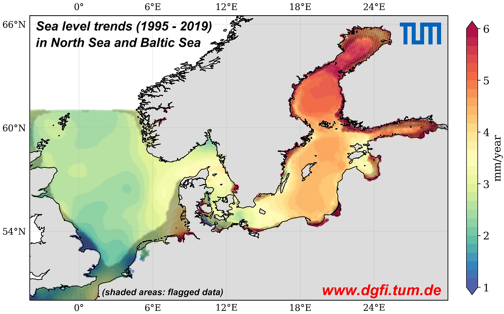
The largest rises in sea levels are occurring in the Bay of Bothnia
The analysis of these data for the Baltic Sea shows the regional effects of the rise in sea levels over the past quarter century: The sea level has risen at an annual rate of 2 to 3 millimeters in the south, on the German and Danish coasts, as compared to 6 millimeters in the north-east, in the Bay of Bothnia. The cause of this large rise: Strong south-westerly winds that drive the waters to the north and eastward. This above-average increase in sea level does not pose a threat to coastal dwellers, however, because the land has been rising since the end of the last Ice Age – currently at an annual rate of up to 1 cm.
“Through the newly developed processes for analyzing and combining radar data, we are now in a position to arrive at precise and reliable conclusions on sea level changes in recent decades for other coastal regions as well,” adds Dr. Denise Dettmering. The researcher has also created a comprehensive data set for the North Sea region: The sea level there is rising by 2.6 millimeters per year, and by 3.2 millimeters in the German Bight. Local trends can be determined using the data set and the user manual – both of which are freely accessible online. “With the data, researchers can verify their climate models, for example, and public authorities can plan suitable protective measures,” says Dr. Seitz.
- Passaro M, Müller FL, Oelsmann J, Rautiainen L, Dettmering D, Hart-Davis MG, Abulaitijiang A, Andersen OB, Høyer JL, Madsen KS, Ringgaard IM, Särkkä J, Scarrott R, Schwatke C, Seitz F, Tuomi L, Restano M and Benveniste J: Absolute Baltic Sea Level Trends in the Satellite Altimetry Era: A Revisit. Frontiers in Marine Science 8:647607, 2021. https://doi.org/10.3389/fmars.2021.647607
- Dettmering, D., Müller, F. L., Oelsmann, J., Passaro, M., Schwatke, C., Restano, M., Benveniste, J., Seitz, F.: NorthSEAL: A new Dataset of Sea Level Changes in the North Sea from Satellite Altimetry, Earth System Science Data [preprint], 2021. https://essd.copernicus.org/preprints/essd-2021-103/
-
The European Space Agency (ESA) provides funding for the development of monitoring programs for various parameters of the Earth system, in particular to measure and analyze essential climate variables (ECVs). The ECVs are key criteria describing changes in the Earth’s climate. One of them is the sea level.
In 2018 the ESA launched a regional study on the Baltic Sea region (Baltic+ Initiative), including aspects of the marine ecosystem. DGFI-TUM is leading the Baltic SEAL project. Other participants are the Technical University of Denmark’s National Space Institute, the Finnish Meteorological Institute, the Danish Meteorological Institute and University College Cork in Ireland. -
The data set is available at:
balticseal.eu
Technical University of Munich
Corporate Communications Center
- S. Reiffert
- stefanie.reiffert@tum.de
- presse@tum.de
- Teamwebsite
Contacts to this article:
Dr. Marcello Passaro
Technical University of Munich
German Geodetic Research Institute (DGFI-TUM)
Tel.: +49 (89) 23031-1214
marcello.passaro@tum.de
Dr. Denise Dettmering
Technical University of Munich
German Geodetic Research Institute (DGFI-TUM)
Tel.: +49 (89) 23031-1198
denise.dettmering@tum.de

")
. The water underneath is subject to a dynamic seasonal process and is influenced by the currents of the Atlantic ocean. (Illustration: Marc")